
Will there be a road bridge to Koh Chang?
This page follows the progress, or lack of it, of the Koh Chang bridge. A proposal to build a road bridge linking the Trat mainland with the island. Scroll to the bottom for the most recent updates.
Background
At the narrowest point the strait is around 6 kilometres wide and the deepest point is 10 – 12 metres. So from an engineering perspective it the distance isn’t too long or the sea too deep for a bridge to be constructed. The strait is also sheltered from storms and prevailing winds during the rainy season and so rough seas are rare.
However, a bridge would put significant stress on Koh Chang’s infrastructure as there is only one road on the island. So the amount of traffic on the island would increase dramatically and there would be problems with tailbacks and more accidents on narrower and hillier stretches of road.
Add to this the issue of the road not currently circumnavigating the island. A 10km section linking the southwest and southeast of the island was never completed and work stopped on it back in 2004. Over the years there have been numerous proposals to complete this, all of which came to nothing. But as of early 2023, it appears that a budget for finally completing the road will be allocated within the next year or two and it will finally go ahead.
Another significant factor is that around 75% of Koh Chang is National Park, so you might expect there would be a priority placed on ecology and the environment. (In which case, you’d be wrong.)
If a bridge were built, it would likely result in a huge increase in the number of tourists, businesses, the amount of waste produced and resources needed to keep them running. For example water is scarce in many places during the high (dry) season and the electricity supply, via undersea cable from the mainland, is barely sufficient at present.
On the plus side, land and property prices on the island and mainland near the bridge would increase dramatically.
The Current Situation
Koh Chang is currently served by one ferry operators. (In the past there were two. One was sold and the new owner promptly ran it into the ground and then closed it a couple of years later. Which ,whether by intent or accident, left Koh Chang with one ferry operator.) The crossing takes around 30 minutes and ferries are timetabled to depart hourly. During busy periods the frequency is increased to every 20 – 30 minutes.
But, for as long as folks can remember, there have always been long queues of traffic waiting for boats during peak periods – such as long weekend holidays and New Year celebrations. And when people have to wait for anywhere up to 3 or 4 hours for a boat, the calls for a bridge get louder.
Interestingly, Ferry Koh Chang, currently the sole proper ferry company, has strong links to one of Thailand’s largest conglomerates. One which owns directly (or indirectly via proxies) a large amount of land on the island and a couple of large resorts. This megacorp has also recently branched out into the civil engineering business and would probably be very interested in getting the contract to build a bridge.
Who’s For It? Who’s Against It?
If it was up to expats and most Western tourists who currently visit the island then a bridge wouldn’t be built. As the character of the island will undoubtedly change. However, no amount of foreigners whining or getting upset on social media is going to change things.
A non-scientific Facebook poll from 2020 showing a very strong anti-bridge sentiment amongst expats and foreign tourists.

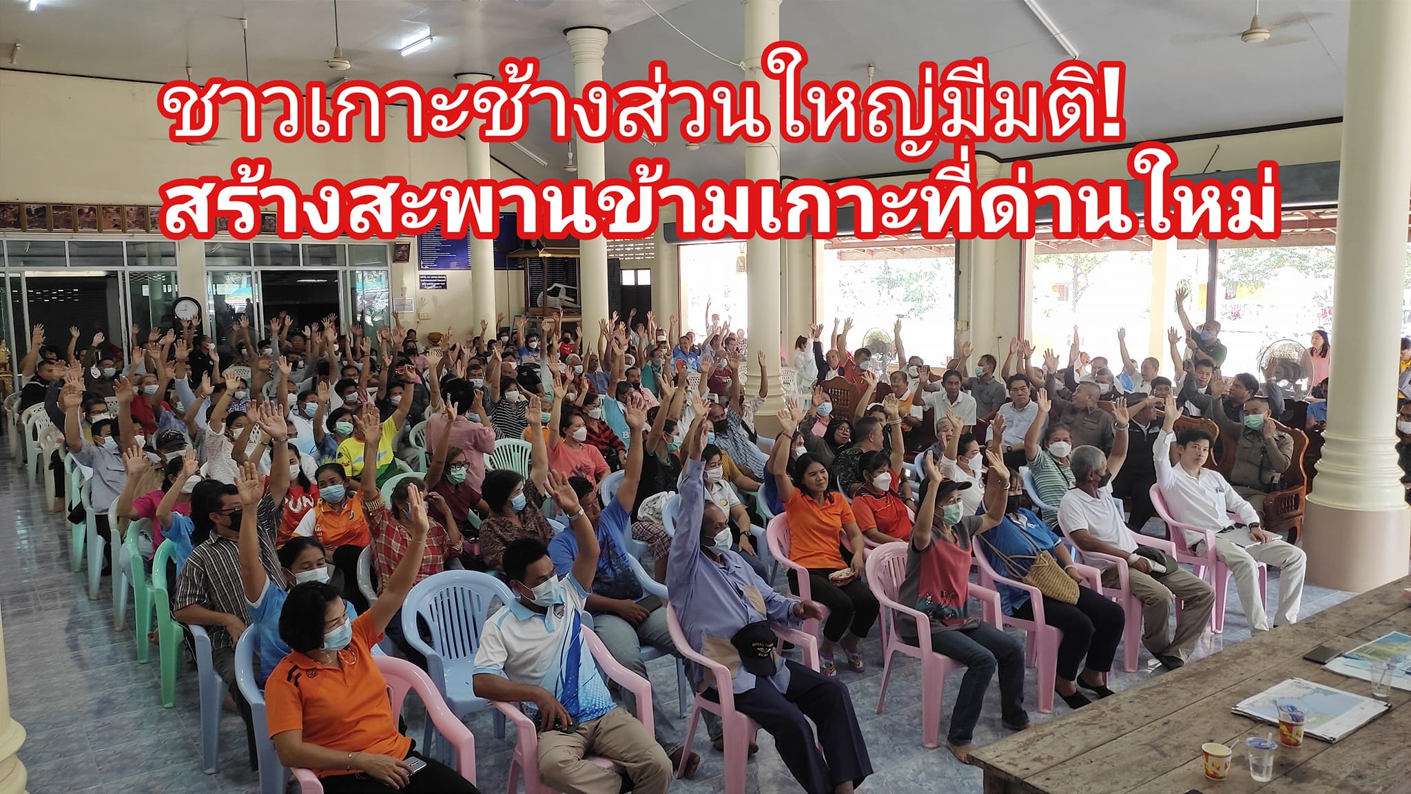
Far more importantly, the overwhelming consensus amongst local residents (and large business owners) on the island is that they want a bridge. When residents of the island, and also Laem Ngop on the mainland, were surveyed over 95% of the total wanted a bridge. Amongst locals on the island the figure was 98% in favour of a bridge.
The photo below is of the almost unanimous show of support from Koh Chang residents at a meeting in early 2023. (Picture from the Thai language ‘Islander’s Voice’ Facebook group.)
The History of the Bridge & Updates
2016
The first meeting to discuss the idea of a bridge was held in October 2016 in which the Koh Chang Hotel and Business Group, local businessmen and counsellors agreed in principle to the bridge’s construction. This didn’t mean it would happen immediately, just that the people attending formally supported the idea. This was followed up in early 2017 with the distribution of several hundred questionnaires in a bid to survey the opinion of local residents.
2018
Fast forward a couple of years to 2018 and the Thai Prime Minister visited the island. Various vote winning infrastructure projects were discussed. However, the bridge wasn’t among them.
2021
In October, the first signs of real progress are reported by The Bangkok Post. A summary of which is below:
According to Somkiat Samatthakan, the chairman of the provincial working committee organizing the hearings, if the project passes this year’s hearing, construction on the bridge is expected to begin next year.
The bridge would provide a convenient and reliable connection between Koh Chang and the mainland, especially during medical emergencies. Currently, the only way for residents and visitors to travel between the island and mainland is by ferry, which takes between 30 to 45 minutes and is only available from sunrise to sunset. During long holidays, the waiting time to board the ferry can result in a travel time of up to four to six hours, causing traffic congestion for kilometers.
The proposed 10-km sea bridge would stretch from Laem Ngop sub-district on the mainland to Ban Dan Kao on Koh Chang. The working committee held the first public hearing for the project four years ago, where 90% of Koh Chang residents expressed their support for the bridge.
The second round of public hearings for Laem Ngop and Koh Chang residents is set to begin later this month and is expected to conclude by November. The results of the hearing will then be submitted to Trat’s Department of Rural Roads office, which will use them to request a budget to commission the bridge’s design and conduct related studies.
2023
More meetings were held in February 2023. The Nation newspaper reported on one.
Trat’s Natural Resources Conservation and Environmental Protection Association’s President, Somkiat Smattakarn, announced the second survey on a proposed bridge to Koh Chang island. The survey aims to collect the opinions of residents in Laem Ngop district on the mainland and Koh Chang islanders.
The first survey conducted four years ago showed that 90% of residents living in both areas were in favor of the bridge. Somkiat stated that the proposed bridge would provide more convenient travel for residents and visitors, especially during medical emergencies at night, and help reduce traffic during the high season.
The survey is set to begin later this month for Koh Chang residents and next month for Laem Ngop residents. The data collected will be handed over to the Trat Rural Roads Office, so it can earmark funds for the proposed 10-kilometer-long bridge that will run between Laem Ngop district, near the Koh Chang Naval War Memorial, and Koh Chang’s Ban Dan Kao area.
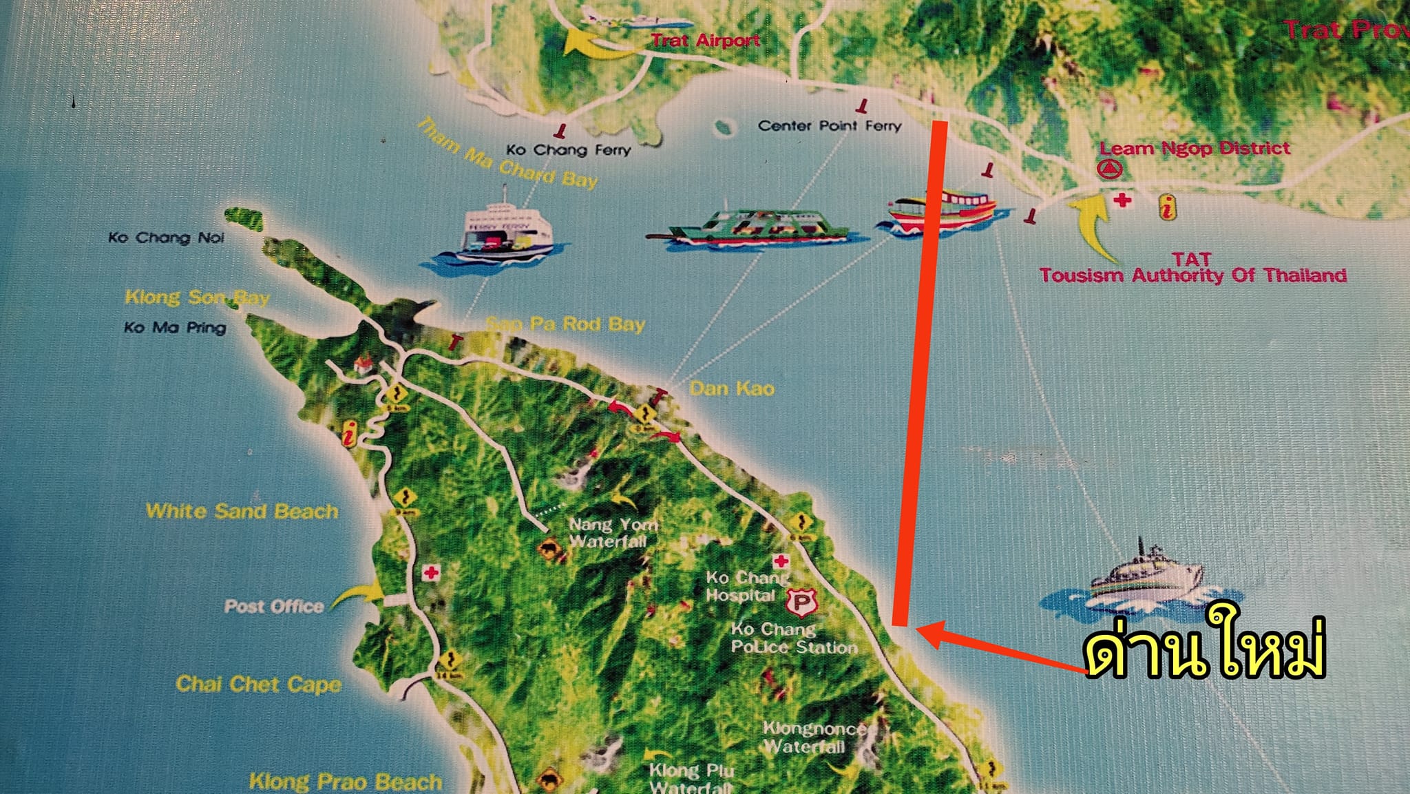
Also in February 2023 there were further meetings with local residents on the mainland and on Koh Chang which discussed the proposed routes for the ferry. Two routes were up for discussion. One of which would be on the path of the current Ferry Koh Chang route. This 6km route is the shortest distance between the mainland and the island. The other is longer, around 7km and lies further south. From Laem Ngop village to Dan Mai, the administrative capital of Koh Chang, about half way down the east coast of Koh Chang.
The two original routes.

The result of these meetings was that the best route for the bridge would be from the area near Krom Luang Naval memorial in Laem Ngop to a point south of Dan Mai village on Koh Chang. This was to avoid having traffic go through the centre of Laem Ngop and Dan Mai villages. It also meant increasing the length of the bridge to nearer 10km.
A budget of 30 million Baht was allocated for a more detailed feasibility study of the new preferred route which is shown below.
Following this meeting a delegation comprising representatives from Trat provincial government, local officials from Koh Chang and Laem Ngop and business leaders visited the Ministry of Transport to formally present the case for a bridge to the Thai government. As final approval and funding will be from them.
Map of Proposed Route
The original plan from March 2023, was for the bridge to start just north of the Naval Memorial near Laem Ngop and run around 10km to a point just south of Dan Mai village on Koh Chang.
This has now changed – see September 2024 update below – So, I have updated the map. There are now four potential routes which are marked below. More details in the update. Ferry piers are marked in yellow.
In early April 2023 Thaipost news reported that Surachet Laopoolsuk, the Governor of the Expressway Authority of Thailand (EXAT), had confirmed that there was an ongoing feasibility study for the project to link Koh Chang to the mainland by bridge. The proposed budget for the bridge is 15 Billion Baht. Interestingly this report states that the length of the bridge would be 6Km – meaning it would be built in a different location to the route that has been put forward as the preferred option by local figures.
September 2023. The latest news is that there’s still a very, very long way to go before it becomes a reality.
A 2 year research and study period will begin at the end of 2023 / early 2024. Once this is completed the Environmental Impact Report (EIA) will be sent to the Bureau of Natural Resources and Environment Policy and Planning to consider. The quickest this could take to get approval is about a year.
Then the plans will be presented to the Ministry of Transport and Ministry of Internal Affairs. If they give the project the green light it will be put out to tender in 2028 with construction starting in 2029. The construction period is likely to be 4 years. So the earliest that there might possibly be a bridge to Koh Chang is in 2033.
And that assumes that there aren’t any obstructions / delays due to politics etc at any stage. And if the feasibility study concludes that it’s not worth the investment or the environmental impact is too great, the project may be terminated within the next 2-3 years during the study stage.
December 2023. An article in a business orientated Thai newspaper discusses the 100 Billion Baht worth of proposed expressway and bridge projects that are in the various stages of planning in Thailand. The Koh Chang bridge still has a length of 6km but the budget is now mentioned as being 10 Billion Baht, down from the 15 Billion previously mentioned in reports. All of these mega projects are being handled by the Expressway Authority of Thailand (EXAT), rather than provincial planning authorities.
The section relating to Koh Chang is translated below.
Meanwhile, the Koh Chang expressway project in Trat province, spanning 6 kilometers with a budget of 10,000 million baht, is currently in the process of bidding for a consulting firm to design the project’s suitability. The consultant is expected to be selected by early 2024, with a study period of approximately one and a half years, or completed by 2025.
If the project can be approved within one year, EXAT estimates that the bidding process can begin during 2028, with the possibility of using the public-private partnership (PPP) model for bidding. Construction is expected to start in 2029, taking four years to complete, with the bridge expected to open in 2033.
The Koh Chang project in Trat province starts in the area of Laem Ngop district, crossing the Gulf of Thailand to end at Koh Chang district. The purpose is to reduce the current long travel time of 2-3 hours by ferry, which carries vehicles to the island, especially during long holidays and festivals. The completion of the project will reduce travel time, benefiting tourists and locals.
Mostly the same information and timeline as in earlier reports. But one key difference. The first mention of a Public Private Partnership. Might that entail the bridge being a toll bridge once completed? And if so, which Thai conglomerate stands the best chance of getting the contract to build it and thus control access to the island?
2024
January 2024. A report in the Daily News confirms that applications are being requested from consulting firms to study the suitability of engineering, economics, finance, and environmental impacts of the project. The budget for the consultancy work is around 72 Million Baht. A consulting firm will be chosen in February and contract for the work signed in early March 2024.
The consultants then have two years to produce their report. This report will also include an Environmental Impact Assessment (EIA) and study and analyze the appropriateness of allowing the private sector to invest in the project.
May 2024. Slightly later than planned, but the consultancy firm for the project has just been appointed. A consortium led by Chotijinda Consultants Co., Ltd had their bid of 70,512,876 Baht accepted. They will spend the next 18 months producing a report on the engineering, economics, finance, and environmental impacts of the project. The report is expected by the end of 2025.
July 2024. Trat TV reporting that a committee, which according to Google translate is called “ Thailand Special Way with the Faculty of Appropriation on Engineering, Economics, Finance and Environmental Impact. Joint Committee Meeting of Public and Private Cooperation to Develop and Resolve Economic Problems in Trade Province. For public relations and dissemination of information “Special official project to connect Koh Chang, Trat province” will begin work on deciding the merits of the two proposed routes. The shorter route which follows the path of the existing Ferry Koh Chang route. Or a much longer route starting in Laem Ngop – which would result in a huge amount of traffic going through a sleepy village.
The consultation process which will study engineering, economics, finance and environmental impacts is expected to take around 2 years.
September 2024. On 2-3 September 2024, the Expressway Authority of Thailand (EXAT) organized the first public hearings in Laem Ngop and on Koh Chang for the study of engineering, economic, financial and environmental impacts of the project.
The objectives were to publicize and disseminate project information to all relevant sectors, including representatives of local communities, government agencies and state enterprises, the private business sector, private organizations, educational institutions, local government organizations, community leaders and the media.
The main topic was the finalizing of the four options for routes the bridge might take. There are now four proposed routes. Two beginning on the mainland near Krom Luang pier, Laem Ngop ( the pier for speedboats to Koh Mak ). And two close to Ao Thammachat pier ( the location of the main ferry pier ).


The Koh Chang ends for both Laem Ngop routes are to the north of Dan Mai village. ( Marked as 1 & 2 on the first plan below ) For one Ao Thammachat route the end point is just south of Ao Sapporot pier, and the other potential location is just north of Amber Sands Resort. ( Marked as 3 & 4 on the second plan below )


Further meetings are planned in the next three months with residents in the areas that are potentially affected by having a huge bridge built in their vicinity.
28 – 20 October 2024 – A team from the Expressway Authority of Thailand (EXAT) who are overseeing the planning visited Koh Chang and the mainland and held consultations with local leaders.
2 – 4 December 2024 – The Expressway Authority of Thailand has has hired a group of consultants, including Chotijinda Consultant Co., Ltd., Asian Engineering Consultants Co., Ltd., Tesco Co., Ltd., M.A. Consultant Co., Ltd., MHPM Co., Ltd., and Team Consulting Engineering and Management Co., Ltd. as consultants for the engineering, economic, financial, and environmental impact study of the bridge to connecting Koh Chang. From 2-4 December the consultants will meet members of the local community and business owners to present the study of the various routes and hear comments and suggestions relating to the route, environment and economic impact etc
2025
March 2025. The route has been selected.
It’s been a bit quiet but the consultants have been busy consulting and in mid-March Trat News reported that of the four proposed routes, Route 3 was favoured.
This is due to a combination of short distance, least disruption to local communities and least effect of the natural environment. It is a 5.9Km route with the mainland end point very close to Ao Thammachat ferry pier and the Koh Chang end between the old Centrepoint Ferry pier and Amber Sands Beach Resort.
A lot of people getting carried away and thinking a bridge is imminent. It’s not.
It’s important to remember the project is in the feasibility study and EIA report preparation phase, which will take 720 days. This started on 30 May 2024. . Following this, assuming it’s approved a budget has to be allocated and construction tenders put out.
No construction work is expected to begin until 2029 at the earliest. Once started, it is anticipated it will take 4 years to complete the project. So if you’re planning on boycotting Koh Chang because of the bridge, you’ve got at least 8 more years of ferry travel to look forward to.

The image below gives an idea of the type of bridge that may be constructed. It will be divided into 2 main sections:
1. General bridge structure: It is a box-beam concrete bridge that supports a 4-lane expressway with 1 service road per side. With a central island and shoulder
2. Extra long span structure (this will be in the middle of the sea) and will comprise an extradosed section, suitable for the middle of the bridge and a balanced cantilever section designed to be resistant to wind and waves, and built to allow ships to pass underneath.

April 2025 Meetings held.
Koh Chang Meeting
On 1 April a meeting was held on Koh Chang and the mainland to allow residents and business owners to learn more about the proposed route, why it was chosen and present any concerns that they have at this stage. On Koh Chang there were over 200 attendees.
Whilst the overwhelming opinion is that the bridge will be good for the island, the main point of contention seems to be the fact that as the bridge is being classed as an expressway, it can only be used for four wheel vehicles and above. This is the same as all expressways in Thailand.
No motorbikes, bicycles, pedestrians or runners will be allowed to use it. This has upset folks who don’t own a vehicle and use scooters as their daily form of transport.
Also there won’t be anywhere to stop and take photos. This has upset people who live their lives out on social media.
Laem Ngop Meeting
Trat residents asked the Expressway Authority of Thailand (EXAT) to review the chosen route. There were three main reasons for this:
This is in contrast to Koh Chang residents just want a bridge and aren’t that bothered where it goes to on the mainland.
– It has to have motorcycle lanes. Self explanatory, and something the islanders agree with. Not allowing motorcycles rules out a large number of people who travel for work or for a vacation by scooter.
EXAT accepted the Trat residents proposals for consideration and but noted that it may not be possible to gain government funding for a 20 Billion Baht ( or more if the full wish list is implemented ). Which would lead to the project being delayed or cancelled.
June 2025 Meeting held
A meeting led by Mr. Dumrong Sak Yodthongdee, the deputy governor of Trat province presented information to public agencies, the private sector and the general public. The meeting was held after receiving previous feedback. It included the opinions of the local people on Koh Chang and the mainland and the results of studies in engineering, economics, finance and environment. The 5.9km long ‘Route 3’ was confirmed as the definite choice of location for the bridge.
But also the project managers and Trat officials will provide incentives for visitors to spend more time on the mainland before coming to Koh Chang. Reduced toll fees in return for shopping or eating on the mainland for example. Schemes for discounted tolls for locals, residents and frequent visitors were also put forward.
The Budget for construction costs was finalized. For a vehicle only bridge = 10,315 Million Baht. With additional lanes for motorbikes = 13,355 Million Baht.

